

The Alto project raises many questions and concerns. Let’s compare how planning for this project is going compared to when Highway 417 was planned and constructed.
The Department of Highways Ontario (DHO) announced the construction of Highway 417 from Pointe-Fortune to Ramsayville (near the present Hunt Club Road interchange) in mid-July 1967. It was in January 1969, as published in The Review, that the DHO clearly stated that concrete steps toward the construction of Hwy 417 were taken, specifically the clearing of land in the Ramsayville sector. The Minister also presented the route Hwy 417 would be taking. Characteristics of the soil made it necessary to choose a southernly route.
The DHO had given the go ahead for the rural part of 417 without knowing how and where it would link to the Ottawa Queensway. It was only in October 1971, that the continuation route of the 417 was made public. Four possible routes were originally studied. It is worth pointing out that the Ottawa Carleton Regional Council had voted in July asking the DHO to choose a different option to what the DHO selected.
Highway 417 was opened in December 1975 from Pointe-Fortune to the Queensway. A rush order had been put on the whole construction due to the Montréal Olympics in 1976.
Comparison of Alto to 417
| 417 | Alto, Montréal to Ottawa | |
| Time to complete from preliminary announcement | Almost 8.5 years | Preliminary announcement in December 2025. Beginning of construction: 2029-2030. To be completed around 2038; 13 years |
| Width of proposed corridor | Four options | The first study corridor is 10 km wide. A narrower corridor, of about 1km, to be presented in fall 2026. |
| Time between preliminary announcement and announcement of the route | 18 months | Annoucement of the ultimate 60-metre-wide right-of-way: date unknown. |
| Consultations | With the Ottawa-Carleton population and mayors. Alexandria and McCrimmon population had a meeting with DHO demanding an interchange at McCrimmon Road | Alto hosted 26 in-person open houses, 10 virtual sessions, 32 stakeholder roundtables and spoke to more than 10,000 Canadians. A public consultation report should be published by summer 2026. |
| Expropriations | Between 1967 and 1971. | As soon as late 2026. |
| Criteria used to choose the pathway | The least expensive | Will be based on distance, results of consultation and studies. |
| Cost per km | Originally $1 million per mile | $60 billion to $90 billion for entire system between Québec City and Toronto. |
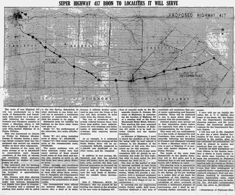
Story and map from the January 30, 1969 edition of The Review
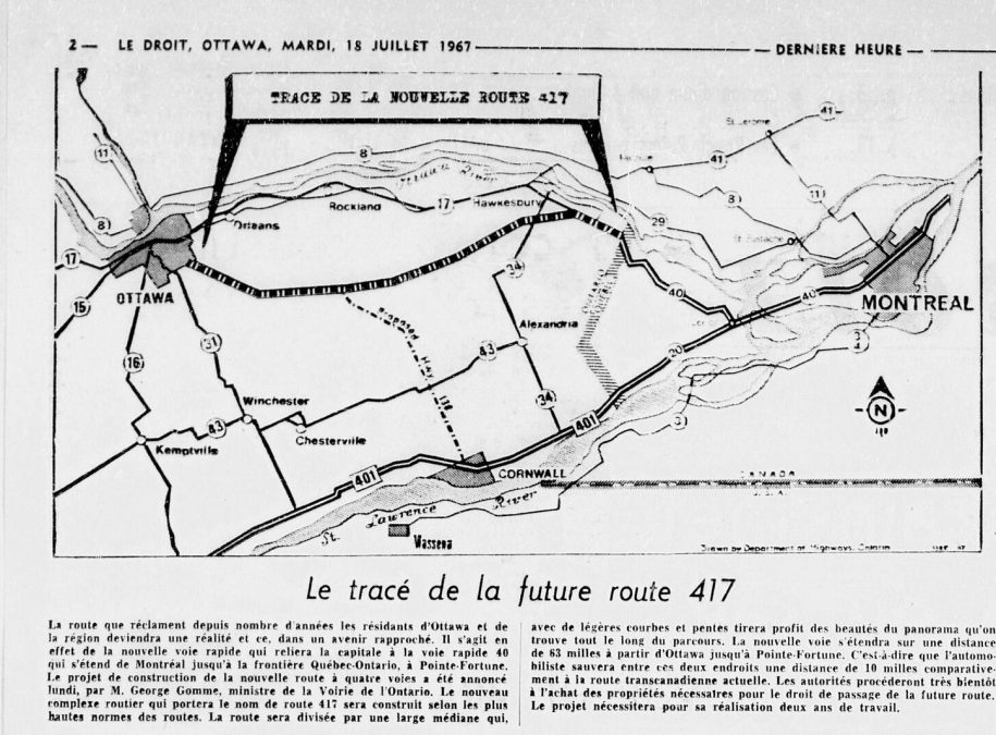
From Le Droit, July 18, 1967.