
Late summer and early fall are the perfect times for a walk in the woods or along the water. The temperature is just right, and the mosquitoes are mostly gone. Across Argenteuil, there are trails of all levels of difficulty for hiking and casual strolling.
Gore offers great opportunities for hiking
For the optimum wilderness experience within easy reach of home, Gore offers great opportunities. Les Sentiers de Gore/Gore Trails organization is a group of volunteers which has constructed and maintains free trails at two locations on municipally-owned property. The idea for Les Sentiers de Gore began in 2013 when a group of residents met and decided their community needed more local hiking opportunities. The organization was founded as a not-for-profit group in 2017. The Pioneers Trail has three loops totaling 3.4 kilometres and begins next to the outdoor rink at the municipal park on chemin Cambria where parking is available. The trail covers mostly rugged, wooded terrain, but also has a boardwalk crossing a bog.
Sentiers de Gore has also constructed and maintains a trail which loops around a large pond at the 60-acre Parc Dénommé, located on chemin Densa. The loop around the pond was fully completed in the spring of 2021.
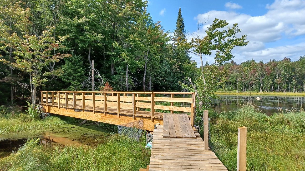
“We just finished building the bridge there,” said Sentiers de Gore President Jean-François Hamilton.
The new bridge crosses a wide stream at the head of the pond and was built by volunteers. This quiet trail travels rolling terrain and passes by a couple of beaver dams. It offers opportunities to see various types of wildlife. A parking lot is located on chemin Densa. Parc Dénommé was donated to the Township of Gore by Marcel Dénommé, a former municipal councillor.
Sentiers de Gore relies entirely on volunteer labour for trail construction and maintenance.
“Things go pretty fast when we have a good gang,” said Hamilton.
Funding comes from the township and the MRC d’Argenteuil and some building materials are donated. The fire department helped with bringing the bridge materials to the isolated site at Parc Denomme.
Les Sentiers de Gore could eventually connect with the trails being developed at the new Parc Lac Beattie in Gore. The 600-acre site opened on July 1, 2021, and parts of the approximately 10-kilometre trail network remain under development.
“We’re very supportive, we hope it works out well,” said Hamilton.
Both of Les Sentiers de Gore trails are open year-round for hiking and snowshoeing.
Lac Beattie
For many years, Lac Beattie was used as a water reservoir for the town of Lachute. The lake is located in Gore, but Lachute owns the land. Water levels on Lac Beattie are controlled by a dam at its outlet, which flows into Lac Sir John.
When Lachute decided to drill wells for its municipal water source, it no longer required the reservoir. Gore Mayor Scott Pearce wanted to be sure the lake and surrounding forest remained available for public use. Gore and Lachute reached a 40-year lease agreement where the township will manage the land as a park and natural area. Separate trails are being developed for mountain biking, and the township is planning to offer cross-country skiing and snowshoeing in winter.
Daily and seasonal fees vary for Parc Lac Beattie for residents of Gore, residents of the MRC d’Argenteuil, and non-residents. For a complete list of rates, go to https://www.cantondegore.qc.ca/en/discover-gore/lake-beattie-park . Access to the park is from chemin Beattie off Route 329.

Lac Beattie. Photo: James Morgan
Boisé Von Allmen
Near Carillon in St-Andre-d’Argenteuil, the Boisé Von Allmen natural area offers short loops of hiking trails through the forest and beside Rivière du Nord.
The trails cross over the various paved routes of the paved Veloroute d’Argenteuil, which passes through the area. Wildlife, especially birds, can be found along the trails.
There are two lookout towers, and the landmark Passerelle Desjardins suspension bridge crosses Rivière du Nord. Access is free and parking is located in lots beside Route 344.

Downstream on Rivière du Nord from the Passerelle Desjardins at Boisé Von Allmen. Photo: James Morgan
Grenville-sur-la-Rouge
Rivière Rouge is one of Canada’s top rivers for whitewater rafting, canoeing, and kayaking.
For people who prefer to stay on dry land while enjoying the river, there is a short trail on the north side of Camping des Chutes de la Rouge. The trail is accessible from the parking lot at the campground on the north side of Route 148, on the east side of the bridge.
The trail winds through the forest and by the rapids at the bottom of the deep, narrow valley where the Rouge makes its final rush toward the Ottawa River. The trail has a bonus for art lovers because it is also home to the outdoor exhibit ‘Nature et Tradition’.
Grenville village
The gravel path on the narrow strip of land between the historic Grenville Canal and the Ottawa River is an easy walk, but if offers the very best of history and nature combined. Parking is at the end east end of rue Canal Sud in the village of Grenville.
The linear path goes from the parking lot to underneath the Long Sault Bridge. Watch for a blue heron on the canal or try fishing from the banks on either side.
There is an abundance of benches, picnic tables, and Adirondack chairs to stop at and enjoy the expanse of the river, or the slow-moving canal that once helped boats bypass the former Long Sault rapids. Several unique trees and plants can also be found along the trail.

The recreational trail in Grenville offers great views of the historic canal and the Ottawa River. Photo: James Morgan