
The municipality of Grenville-sur-la-Rouge and the Municipalité régional du Comté (MRC) d’Argenteuil want to hear from residents and organizations about mining claims within its territory.
The MRC is holding a series of forums on Territories Incompatible with Mining Activities (the French abbreviation is TIAM) and wants input from local property owners about mining which could take place on their properties. The process is being conducted under provisions of Québec’s Mining Act which permits regional governments to advise the government that certain lands are incompatible with mining activities.
“It’s really the MRC that does the show, not us,” said Grenville-sur-la-Rouge Councillor Denis Fillion at a public meeting held on TIAM on November 12.
The MRC wants to add any incompatible lands to those already included on the the existing TIAM map.
“Those are things we want to make sure don’t fall through the cracks,” said Grenville-sur-la-Rouge Mayor Tom Arnold.
He said it is important that no properties are missed during the process.
The TIAM process in Argenteuil comes amid a legal confrontation between the Grenville-sur-la-Rouge and a mining company that wants to begin operations in the municipality.
Fillion explained that the idea behind TIAM is to protect territories that are considered to be incompatible with mining activities. According to the maps, that is most of the MRC. The incompatible lands include urban areas, and properties that are residential, commercial, or industrial. The entire Ottawa River frontage area is incompatible, along with properties that are of significance for heritage, tourism, or environmental conservation.
However, there are existing mining claims in place that are protected, and some claims will not be renewed if no exploration work is done on them during the period the claim is valid — prior to it being added to the TIAM. There are approximately 98 claims in total, and 91 of them are in Grenville-sur-la-Rouge. Six are in St-André-d’Argenteuil and one is on the border of Wentworth and Gore. Based on the MRC’s TIAM map, there is land considered to be incompatible with mining in part of every claim. The map also indicates that mining is still a compatible use within part of 41 claims.
If incompatible lands are added to the TIAM map, prospecting, exploration, and mining would not be permitted within them. However, citizens need to submit the required information if they believe part of their property is incompatible and is not indicated as such on the TIAM map.
The MRC is holding two bilingual consultation meetings for those whose properties are located in claim areas. The first session on Friday, December 6 is for organizations and partners. It takes place from 1:30 p.m. to 4:30 p.m. in the basement of Église St-André-Apôtre at 1 route des Seigneurs in St-André-d’Argenteuil. The meeting for citizens is on Saturday, December 7 from 1:30 p.m. to 4:30 p.m. in the gymnasium at Seminaire du Sacré-Coeur, located at 2738 Route 148 in Pointe-au-chêne. Affected residents and stakeholders have received invitations to the meetings. Participants must pre-register at argenteuil.qc.ca
Residents who live in claim areas are also encouraged to provide any further information they have about why mining might not be suitable in their area. They can submit it to the MRC by email at [email protected] before January 6, 2020 or by making notes directly on the interactive map on the MRC website.
A six-month moratorium on new mining titles is currently in effect in Argenteuil. The MRC to the Québec government for the moratorium while it goes through the TIAM process. The moratorium can be renewed if necessary. Once the TIAM process is complete, the development scheme for the region will be updated to reflect the changes.
More information on the TIAM process, including maps, is available on the MRC d’Argenteuil website at https://www.argenteuil.qc.ca/accueil/affichage.asp?langue=1&B=191 .
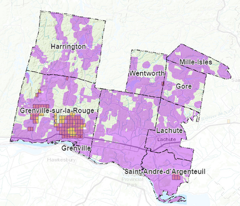
An MRC d’Argenteuil TIAM map. The small rectangles indicate boundaries of mining claims. The light purple areas are territories that are proposed to be incompatible with mining. The orange shading indicates areas within mining claims that do not presently have any designation of incompatible uses. The darker purple shading indicates territory where mining activities could take place but are within territories that are considered incompatible. Source: MRC d’Argenteuil.