
New natural hazard maps to identify flood risks along the Ottawa River and its tributaries are now official, but only in Alfred and Plantagenet and Clarence-Rockland.
According to South Nation Conservation (SNC) Communications Specialist Erin Thorne, the new maps were adopted by the SNC board in April, 2023. SNC, in partnership with the United Counties of Prescott and Russell (UCPR), received support from the Government of Canada to update the natural hazard maps along the Ottawa River, following the historic floods of 2017 and 2019. This area was previously mapped in the 1980s by Environment Canada.
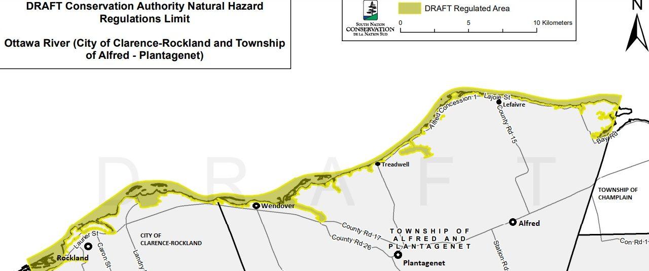
The new study was completed for the entire shoreline, from Clarence-Rockland’s western boundary near Cumberland to the Carillon Dam. State of the state-of-the-art digital topographical information was used, along with water resource modelling and field surveys to better understand the river morphology, water flows and the location of the floodplain in various storm events.
“Thanks to new LiDAR technology and topographic information, erosion hazards were also defined during this study to help ensure that new construction can be directed away from steep and highly erodible slopes,” Thorne explained.
While SNC completed the floodplain and erosion mapping for the entire Ottawa River shoreline earlier this year within the United Counties of Prescott-Russell, the Conservation Authorities Act regulations for alterations to shorelines and watercourses can only be enforced and adopted for regulation in areas within SNC’s jurisdiction, which includes the two municipalities of the City of Clarence Rockland and Alfred and Plantagenet. The responsibility for shoreline development in areas without Conservation Authorities falls within the mandate of the Ministry of Natural Resources and Forestry and the local municipality. The Town of Hawkesbury, and the townships of Champlain and East Hawkesbury are not part of the conservation authority.
If the Town of Hawkesbury, the Township of Champlain and the Township of East Hawkesbury wish for the Conservation Authority’s help to ensure safe shoreline development and work within natural hazards, a jurisdiction expansion request would need to be initiated by the municipality and approved by the rest of SNC’s 16 member municipalities.
“As a result of increased economic and community development and related shoreline construction issues, the Township of Alfred Plantagenet expanded SNC’s jurisdiction in 2014 and the City of Clarence-Rockland expanded SNC’s jurisdiction in 2020,” Thorne said.
Since joining SNC, the two municipalities have been able to access the agency’s Flood Forecasting and Warning Programs and Floodplain Mapping and Regulatory Permitting Programs to help ensure new development along the Ottawa River is safe and sustainable.
Public consultations on the new map proposals were hosted by SNC in March 2023 for the areas within Alfred and Plantagenet and Clarence-Rockland. Following the consultation and peer reviews, SNC adopted the new mapping in April 2023 for the shorelines within the City of Clarence-Rockland and the Township of Alfred-Plantagenet.
Natural hazard maps are used by municipalities and SNC when updating Official Plans for land use, and zoning schedules, and when reviewing development applications. The idea of the maps and the regulations regarding floodplains and other natural hazards are intended to protect people and property from natural hazards and guide sustainable development activities.
Development projects within natural hazard areas such as floodplains require permission from the conservation authority before proceeding. For further regulatory information, visit SNC’s Regulations Webpage to learn more about regulations made under Section 28 of the Conservation Authorities Act, (Ontario Regulation 170/06 Regulation of Development, Interference with Wetlands and Alteration to Shorelines and Watercourses).
To view the draft maps, including with specific detail by property address, Click here to access the Interactive Property Map.